United States Regions
There are many ways to split the U.S. into regions based on various features. Some regions are defined by the government, while others are based on culture, history, geography, economy, and other factors.
This page contains maps of commonly described regions in the United States. Some of the maps are available for free download as WordPress plugins.

Contents
Survey: How Would You Divide the U.S. Into 5 Regions?
On the interactive map below, divide the 50 states into the following regions - the Northeast, the Midwest, the South, the Frontier, and the Pacific.
When you have distributed all the states by region, click “Submit” to see the current results of the survey. The poll started on May 17, 2022.
This poll was inspired by the article "How America divides itself fivefold" (by Aleksandr Trubetskoy), which analyzed the responses of over 600 Americans in a similar survey. In addition to the five regions listed, some responses also contained the following regions - Big Sky and Atlantic.
Official Regions
The United States is a diverse country. This is why it is difficult to divide the country into regions that are all homogeneous. Different government agencies have different options for dividing the United States into regions, and each division has its own set of advantages and disadvantages.
Census Bureau-Designated Regions and Divisions
The US Census Bureau splits the country into four regions with nine divisions for data collection: the Northeast, the Midwest, the South, and the West.
WordPress Plugin for U.S. Census Bureau Regions and Divisions
- WordPress plugin with a fully visual interface, no coding required
- License: Free for commercial and personal sites
Standard Federal Regions in the US
In 1974, the Office of Management and Budget (OMB) established ten regions to be used by all federal agencies. These ten regions are labeled Region I through Region X, each composed of several states.
WordPress Plugin for Standard Federal Regions
- WordPress plugin with a fully visual interface, no coding required
- License: Free for commercial and personal sites

Cultural and Geographical Regions in the US
The US can also be divided into cultural or geographical regions. Cultural regions are grouped depending on shared cultural characteristics, while geographical regions are sorted by their physical location on the continent.
Below are examples of some interesting maps, available for download as WordPress plugins.
- Alaska
- Appalachia
- Great Basin
- Great Lakes
- Great Plains
- Gulf Coast
- Hawaii
- Inland Northwest
- Inner/Interior Midwest
- New England
- Northeast Highlands
- Northeast Megalopolis
- Pacific Northwest
- Pacific Southwest
- Rocky Mountain West
- South Florida
- Southwest
- Texas
- The South
- Tidewater
WordPress Plugin for U.S. Map Regions
- WordPress plugin with a fully visual interface, no coding required
- License: Free for commercial and personal sites, attribution required
Frequently Asked Questions
Below you can find the most common ways to divide the U.S. into different numbers of regions.
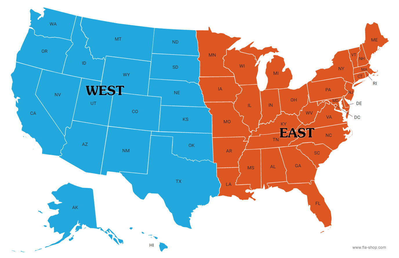
What are the 2 regions of the US?
West and East.
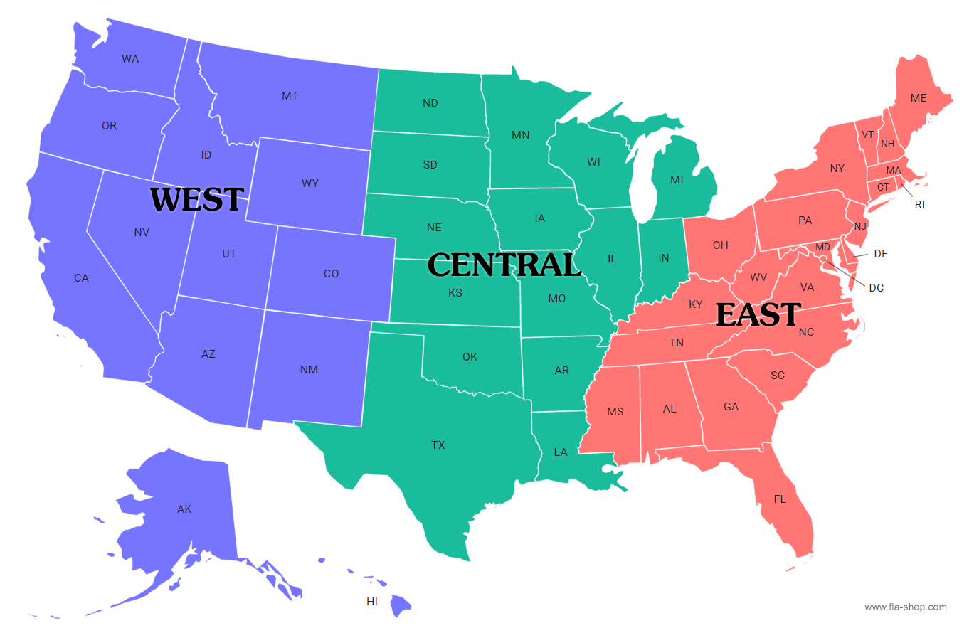
What are the 3 regions of the US?
When divided into three regions it is usually West, Central and East.
What are the 4 regions of the US?
The Census Bureau divides the US into four statistical regions: the Northeast, the Midwest, the South, and the West.

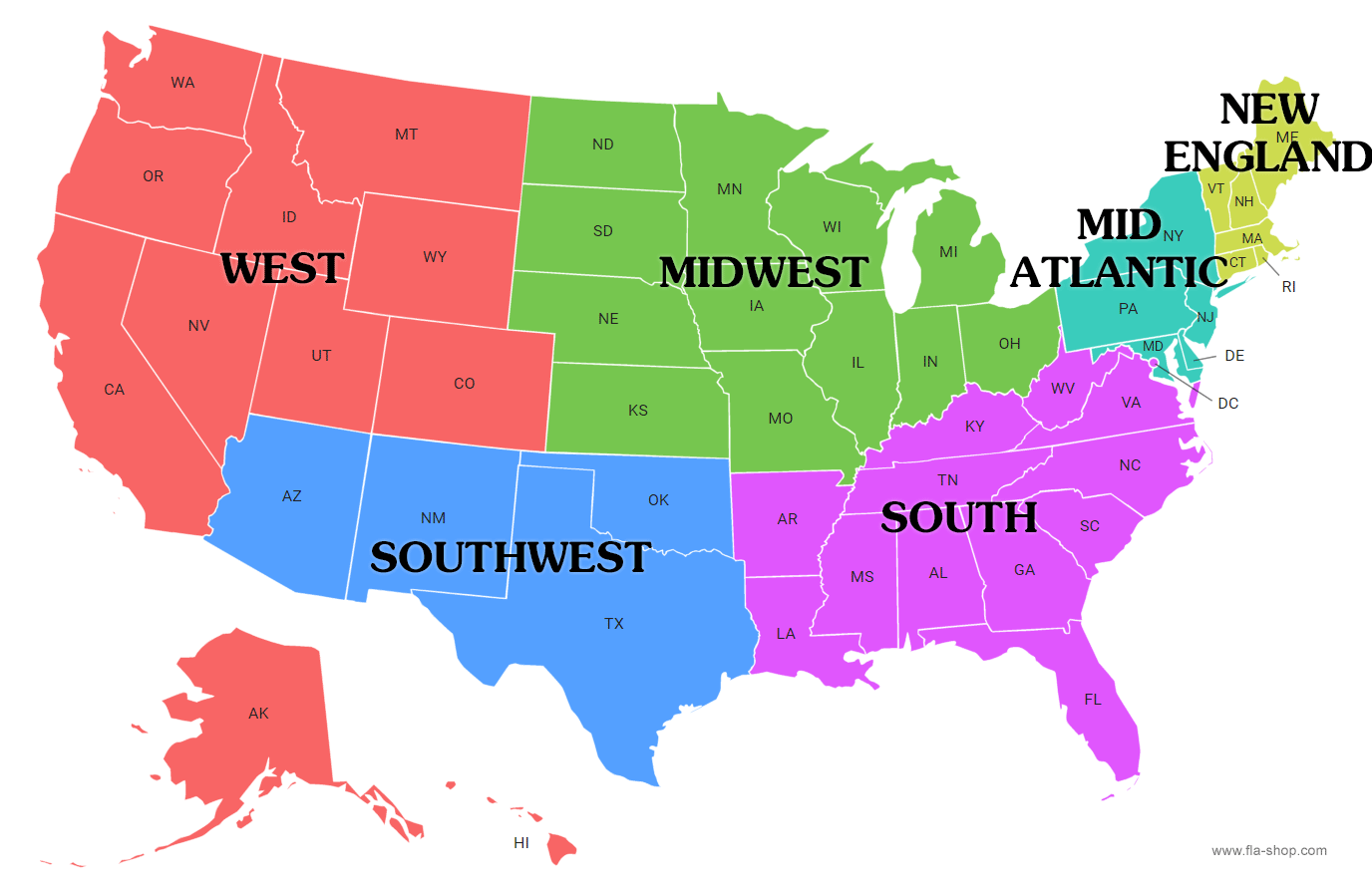
What are the 5 regions of the US?
A common way of referring to regions in the United States is grouping them into 5 regions according to their geographic position on the continent: the Northeast, Southwest, West, Southeast, and Midwest.

What are the 6 regions of the US?
The US can be divided into six regions: New England, the Mid-Atlantic, the South, the Midwest, the Southwest, and the West.
What are the 7 regions of the US?
The US can also be split into seven regions: the Northwest, the Southwest, the Midwest, the South, the Great Lakes, the Southwest, and the New England.

What are the 8 regions of the US?
The Bureau of Economic Analysis divides the country into eight regions: New England, the Mideast, the Southeast, the Great Lakes, the Plains, the Southwest, the Rocky Mountains, and the Far West.

What are the 9 regions of the US?
The Census Bureau’s four regions can be split into nine divisions: New England, the Mid-Atlantic, the East North Central states, the West North Central states, the South Atlantic states, the East South Central states, the West South Central states, the Mountain states, and the Pacific states.

- New England (Connecticut, Maine, Massachusetts, New Hampshire, Rhode Island, and Vermont)
- Mid-Atlantic (New Jersey, New York, and Pennsylvania)
- East North Central (Illinois, Indiana, Michigan, Ohio, and Wisconsin)
- West North Central (Iowa, Kansas, Minnesota, Missouri, Nebraska, North Dakota, and South Dakota)
- South Atlantic (Delaware, Florida, Georgia, Maryland, North Carolina, South Carolina, Virginia, Washington D.C., and West Virginia)
- East South Central (Alabama, Kentucky, Mississippi, and Tennessee)
- West South Central (Arkansas, Louisiana, Oklahoma, and Texas)
- Mountain (Arizona, Colorado, Idaho, Montana, Nevada, New Mexico, Utah, and Wyoming)
- Pacific (Alaska, California, Hawaii, Oregon, and Washington)
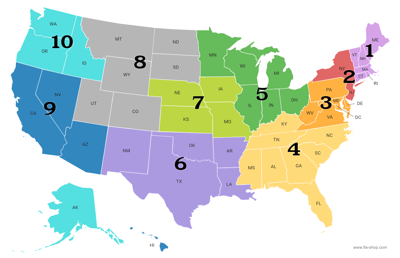
What are the 10 regions of the US?
In 1974, the OMB established ten federal regions, each labeled Region I through to Region X.
Make Your Website More Interactive with Help from Fla-Shop.com
If you want to boost your website’s interactivity, consider getting an Interactive US Map from Fla-Shop.com today!

The Interactive US Map plugin for WordPress allows creating custom territories by grouping states. Create any custom regions, or use a map with clickable states.