WordPress US Map Plugin: Complete Overview
The Fla-shop WordPress US Map Plugin lets you add a customizable, clickable map of the United States to a WordPress website. You can color individual states, display tooltips or side-panel content, add links and markers, organize states into groups, and manage multiple maps directly from the WordPress dashboard.
The plugin is designed for sales territories, dealer and distributor networks, representative directories, office locations, regional data, and other projects organized by US state.
This overview explains how the Fla-shop WordPress US Map Plugin works and introduces each section of its interface, with links to detailed setup guides.
Ready to explore the map?
Visit the product page to see examples, download the demo plugin, and compare the current license options.
Plugin guide
Use this overview as the main entry point to the documentation:
What can you create with the plugin?
The plugin is designed for websites that need to present information by US state, by a custom group of states, or by specific locations placed on the map.
- Sales territory maps
- Dealer and distributor directories
- Representative contact maps
- Office and service location maps
- Regional statistics and data visualization
- Election, demographic, or business data
- State-based website navigation
- Interactive infographics
- Maps with links to state-specific pages
For example, a company can divide the country among several sales representatives, color each territory differently, and show the appropriate contact information when a visitor clicks a state. A directory website can use every state as a link to a local page. A nonprofit organization can use colors to display the status of a program across the country.
Try the Interactive US Map
Click a state in the map below to see how the plugin can display location-specific information. This live example demonstrates clickable states, custom colors, tooltips, and content displayed next to the map.
This example was created with the Fla-shop WordPress US Map Plugin. Map colors, content, links, groups, and markers can all be customized from the WordPress dashboard.
How the WordPress US map works
The basic workflow is straightforward:
- Install and activate the plugin.
- Create a new map in the Maps Dashboard.
- Configure the overall map appearance and behavior.
- Customize individual states, groups, and markers.
- Test the result in Preview.
- Copy the shortcode and add it to a WordPress page or post.
You can create multiple map configurations. Each map has its own shortcode, so the same WordPress website can display different maps on different pages.
For installation instructions, see how to install a Fla-shop WordPress plugin.
WordPress US Map Plugin interface overview
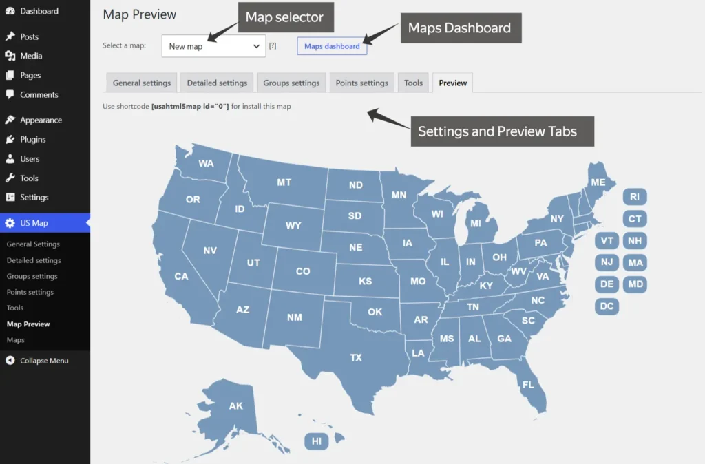
The interface is divided into sections. Some settings affect the entire map, while others apply to individual states, custom groups, or points placed on the map.
Maps Dashboard
The Maps Dashboard is the central management area for all maps created with the plugin.
From this page, you can:
- Create a new map
- Open an existing map for editing
- View the shortcode assigned to each map
- Delete maps that are no longer needed
- Export selected maps to a JSON file
- Import maps from a JSON backup
- Move map configurations between compatible WordPress installations
- Create backups before major changes or a website migration
JSON export is useful for regular backups, staging-site work, and moving a finished configuration to another website.
Read the Maps Dashboard, JSON export, import, and backup guide.
General Settings
General Settings control the appearance and behavior of the map as a whole. This is where you establish the basic presentation before customizing individual states or markers.
Typical options include:
- Map name and general configuration
- Responsive sizing and map dimensions
- Default state colors and borders
- Labels and visual styling
- Tooltip appearance
- Content display mode and placement
- Initial content shown before a state is selected
- General interaction settings
These controls help the map match the WordPress theme and determine how state-specific information appears to visitors.
Detailed Settings
Detailed Settings are used to configure individual states. Each state can have its own appearance, content, and behavior.
- Displayed name and abbreviation
- Main color and hover color
- Tooltip text
- Additional content
- Images
- Links
- Click behavior
This makes it possible to use one map for several purposes at the same time. California could link to a regional landing page, Texas could display a representative’s contact details next to the map, and a state without an active location could show a message such as “Looking for partners in this state.”
Group Settings
Group Settings allow several states to behave as one custom region. This is especially useful when the structure of your business does not follow individual state boundaries.
Common examples include:
- Sales territories
- Service regions
- Dealer networks
- Company divisions
- Statistical regions
- Multi-state franchises
You can select the states included in a group and assign shared colors, content, images, links, or actions. For example, Washington, Oregon, and Idaho could form a Northwest territory with one representative and one set of contact details.
Points Settings
Points are markers placed on top of the map. They are useful when a specific location matters more than the state as a whole.
Points can represent:
- Offices
- Stores
- Warehouses
- Headquarters
- Dealers
- Service centers
- Project locations
- Cities served by a representative
A point can have its own name, label, color, hover color, tooltip, link, image, and content. Points are added and positioned visually on the map; they are not generated automatically from latitude and longitude coordinates.
States and points can also work together. A state click can display regional information, while markers identify specific offices or dealers within that region.
Tools
The Tools section is intended for bulk editing, data transfer, integrations, and advanced customization.
Its main functions include:
- Exporting state and point settings to CSV
- Editing map data in spreadsheet software
- Importing updated data from CSV
- Identifying the internal IDs of map areas and points
- Adding Custom JavaScript
- Connecting map events with other scripts or WordPress plugins
CSV import and export are especially helpful when a map contains a large amount of data. Instead of editing every state separately, you can update labels, colors, links, and content in a spreadsheet and import the result back into the plugin.
Custom JavaScript is intended for advanced scenarios, such as responding to state clicks, filtering content, or passing the selected state to another component. Normal map setup does not require JavaScript.
Preview
The Preview section lets you test the map before placing it on a public page.
Use Preview to check:
- State and group colors
- Hover effects
- Tooltips
- Links
- Additional content
- Markers
- Click actions
- Responsive behavior
- The shortcode assigned to the selected map
Preview is particularly useful after importing CSV data, changing group settings, or adding several points.
Ways to display information
The plugin supports several ways to present content. The best option depends on how much information you need to show and what you want visitors to do after interacting with the map.
Tooltips
Tooltips appear when a visitor moves the pointer over a state, group, or point. They work best for short information such as a state name, representative name, phone number, brief status, or short description.
Content beside or below the map
An additional content area can show more detailed information after a visitor clicks a state or group. It is suitable for contact details, formatted descriptions, images, addresses, opening hours, lists of services, and related links.
This approach keeps the map visible while providing more room than a tooltip.
Direct links
States, groups, and points can open URLs. This is useful when the map acts as website navigation. For example, each state can link to a dedicated landing page, local directory, office page, or regional product catalog.
Custom actions
Advanced behavior can be added through Custom JavaScript. This is useful when a map selection needs to trigger another script, filter a list, or interact with a third-party plugin.
Common use cases
Sales territory map
Combine states into custom regions, assign each territory a color, and display the appropriate representative when the region is selected. A territory map helps visitors find the correct contact without searching through a long staff directory.
Dealer or distributor map
Use states to show regional dealer information and points to identify individual locations. States without an active dealer can remain inactive or display a message inviting new partners.
Representative map
Add a representative’s name, email address, phone number, image, and service area. The information can appear in a tooltip for a compact layout or in the additional content area for a more detailed profile.
Regional data visualization
Apply different colors to states or groups to represent categories, values, performance levels, election results, availability, or program status.
The plugin is designed for interactive state-level presentation. It is not a street map and does not provide routes, turn-by-turn navigation, geocoding, or automatic marker placement from geographic coordinates.
State-based website navigation
Turn each state into a link to local content. This works well for national directories, franchises, service businesses, membership organizations, and websites with regional pages.
Installing and publishing the map
The plugin is installed from a ZIP archive through the standard WordPress plugin installer:
- Open Plugins → Add New.
- Select Upload Plugin.
- Choose the plugin ZIP file.
- Install and activate the plugin.
- Open the map section in the WordPress dashboard.
- Create or edit a map.
- Copy its shortcode from Preview or the Maps Dashboard.
- Insert the shortcode into a page or post.
The shortcode can also be placed in page builders and WordPress editors that support shortcode output.
WordPress plugin or JavaScript map?
Fla-shop offers the US map in both WordPress and self-hosted JavaScript formats, but the management process is different.
| WordPress plugin | JavaScript map |
|---|---|
| Managed in the WordPress dashboard | Managed through map files and settings |
| Visual configuration interface | Designed for non-WordPress websites |
| Inserted with a shortcode | Embedded with HTML and JavaScript |
| No coding required for normal setup | Basic HTML knowledge may be useful |
| Map data stored with the WordPress installation | Map files hosted by the website owner |
This overview focuses on the WordPress version. For a non-WordPress website, see the JavaScript/HTML5 option on the US Interactive Map product page.
Important considerations
- The map is intended for state-level interaction rather than street navigation.
- Points are positioned visually and are not generated automatically from latitude and longitude.
- The US map plugin license contains the United States map rather than the entire catalog of countries.
- Normal map setup is visual, but unusual integrations may require Custom JavaScript.
- Large datasets are easier to maintain through CSV import and export.
- JSON export should be used for backups before major changes or website migrations.
Demo, licensing, and support
A demo version is available for testing the interface and core features before purchase. Current license options, pricing, update terms, and support information are listed on the product page so this documentation remains useful when commercial terms change.
Try the plugin before purchasing
Download the WordPress demo from the product page and create a test map with your own colors, state content, groups, and markers.
Frequently asked questions
Can I create a clickable US map in WordPress without coding?
Yes. Standard configuration is handled through the visual WordPress admin interface. You can customize states, links, tooltips, groups, markers, and content without editing code.
Can every state have different content?
Yes. Detailed Settings allow each state to have its own colors, label, tooltip, image, link, content, and click behavior.
Can several states share the same settings?
Yes. Group Settings let you combine states into a region and assign shared colors, content, links, and actions.
Can I show information next to the map?
Yes. State or group content can be displayed in an additional information area placed beside or below the map.
Can I add office or dealer markers?
Yes. Points can be positioned visually on the map and configured with their own labels, colors, tooltips, links, images, and content.
Can I import state data from a spreadsheet?
Yes. The Tools section supports CSV export and import, which is useful for bulk editing map data.
Can I create more than one map?
Yes. You can create multiple maps with different configurations, and each map has its own shortcode.
How can I back up a map?
Export the required map from the Maps Dashboard to a JSON file. The file can later be imported into the same or another compatible plugin installation.
Does the plugin use Google Maps?
No. It is an interactive vector map built around clickable US states, custom regions, content, links, and points. It is not intended for addresses, routes, satellite imagery, or street navigation.
Does the plugin work with Gutenberg and page builders?
The map is inserted with a shortcode, so it can be placed in WordPress editors and page builders that render shortcode output.
Can I add Custom JavaScript?
Yes. The Tools section supports Custom JavaScript for advanced interactions and integrations. Regular map setup does not require it.
Start creating your interactive US map
The WordPress US Map Plugin can be used as a simple clickable state map or developed into a more advanced territory, dealer, representative, or regional data tool. Start by creating a map in the dashboard, configure its general appearance, add state content, and then extend it with groups, points, CSV data, or custom integrations as needed.
Use this overview as the central reference for the plugin, and follow the detailed guides for each section of the interface: