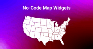
Embedded Maps: add interactive maps to any website—without code
Embedded Maps is a hosted solution for building and publishing interactive maps. In a few clicks, you can customize a map, grab a short embed code, and paste it into any page—no technical skills required. It’s designed for website owners, marketers, agencies, and beginners in web development who need results fast.
The widget works smoothly with popular site builders and CMSs. Whether you use Wix, Squarespace, GoDaddy, Weebly, or a custom site, you’ll be able to embed map on website pages in minutes. The service hosts everything for you and delivers a fast, mobile-friendly interactive map widget that looks great everywhere.
Live Example: Interactive USA Map with Sidebar
Below you can see an embedded map of the United States.
Click on any state to view details in the sidebar panel — the same way your visitors will interact with maps on your site.
Key Benefits
- Easy, visual customization
From regional colors to hover effects, markers, and tooltips—everything happens in a clean, visual editor. You don’t have to edit SVGs or write JavaScript. Pick colors, type your text, drag a marker, and hit Save. - Works with any website builder
The output is a short installation snippet you paste into your builder’s “Embed” or “Custom HTML” block. Because it’s hosted, you don’t manage files or libraries, and compatibility remains simple across Wix, Squarespace, GoDaddy, Weebly, and more. - Mobile-friendly and responsive
Maps scale fluidly across devices. On larger screens, you may show details in a side panel; on narrow screens, the same content appears in a lightweight modal. This ensures a consistent UX whether your visitors are on desktop or mobile. - Built for speed and clarity
The editor focuses on the essentials: colors, labels, tooltips, links, markers, and preview. That keeps your workflow fast and your map clean—no hidden complexity, no bloated options. You can even download a static PNG for presentations or quick mockups when needed. - Free trial, then flexible plans
Start free and test embedding on your live site. After the trial, pick a plan that matches how many maps you need to publish (great for teams and agencies managing multiple sites). Upgrading removes the trial banner and unlocks higher map counts.
How It Works (Step-by-Step Overview)
In short: create a map → customize it → publish → paste the embed code into your website.
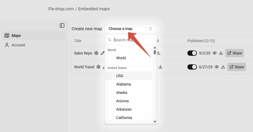
Step 1 — Create a map in your account
Sign in and choose the map you need (e.g., USA, World, European countries, individual U.S. states with counties, and more). Your account dashboard keeps all maps in one place and shows draft vs. published status at a glance.
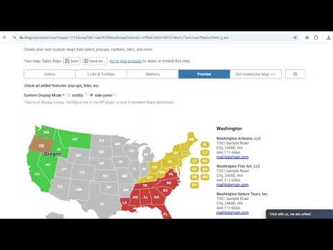
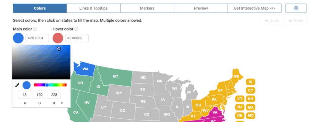
Step 2 — Customize in the editor
After creating a new map, the visual editor opens automatically. Use the tabs to customize colors, tooltips, and markers.
- Colors: choose a Main color and a Hover color as your fill tool, then click on regions to apply them. You can pick any colors you like and adjust regions individually or apply them to all at once via the Gear menu.
- Links & Tooltips: choose a region, then add text, bullet points, links, and other content. This is where you turn a plain map into a helpful, contextual guide.
- Markers: double-click to drop a marker, edit its label, color, icon type, size, link, and tooltip. Drag it to reposition.
- Preview: test your map in both Tooltip and Side Panel modes to see exactly how visitors will interact.
Try it first—no sign-up required: 👉 Try the editor online
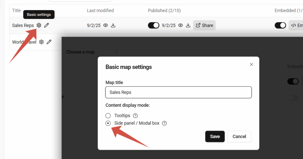
Step 3 — Choose how details appear
In Basic Map Settings, pick your Content Display Mode:
- Tooltips for lightweight hover/click info, or
- Side Panel / Modal Box for longer descriptions and structured content (e.g., office lists or event details). On wider layouts (over ~992px), the side panel appears; on narrower ones, the content opens in a modal—so your map stays readable on phones.
Step 4 — Publish and embed
When your map is ready, publish it in your account and enable embedding. Then click the Embed Code button to open the Installation code window, where you can copy the snippet.
In your website builder, add an Embed or Custom HTML block and paste the code—done. You can always return to the editor, make changes, and republish; your embedded map will update accordingly.
Use Cases & Examples
Interactive maps aren’t just “nice to have.” They help people understand context instantly. Here are practical ways organizations use Embedded Maps:
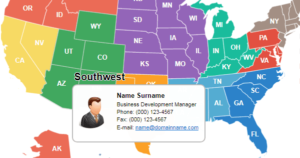
- Sales territories & partner directories
Color regions by territory, add links to local reps, and list partners. A side panel can show contacts, phone numbers, and emails when a region is selected—perfect for B2B sites and channel programs. - Events & venues
Present venues, zones, or routes for conferences, festivals, or city tours. Visitors can tap a region to view schedules, speaker lists, or venue access instructions. - Tourism & travel blogs
Highlight destinations, trips, and itineraries. Bloggers can use markers to add quick facts or link out to detailed posts, galleries, or booking pages. - Research, NGOs & education
Show regional statistics, program footprints, or resource maps. Tooltips can summarize key metrics, while side panel mode holds richer narratives and calls to action. - Media & editorial storytelling
Enrich articles with a map that readers can explore, from election coverage to regional profiles or historical timelines.
Plans & Pricing
Embedded Maps is intentionally simple: all paid plans include the same editing and embedding features. The only difference is how many maps you can create and publish under your subscription. This makes it easy to start small and scale as your portfolio grows.
- Free
Ideal for evaluation and quick demos. You can embed a map with a 7-day trial. After that, a small banner appears on embedded maps as a reminder to upgrade. The editor still works, so you can continue experimenting or switch to a paid plan at any time. - Lite
Best for solo site owners who need to publish a small number of maps—think a company site with a branch locator and one or two campaign pages. Same capabilities as higher plans, just a smaller map allowance. - Pro
Designed for growing teams, marketing departments, or multi-site businesses that need more published maps simultaneously. Great if you run seasonal campaigns, maintain several landing pages, or manage multiple properties. - Pro+
Tailored for agencies and large teams. Use it when you manage a broader portfolio—client sites, microsites, or multiple languages—and need a higher number of active maps without juggling accounts. All features are included; pricing reflects the larger map quota.
Important: Feature-wise, all paid tiers are the same. You’re choosing the map count that matches your workload. If your needs grow, upgrade at any time to increase your allowance.
Related How-to Guides
If you already use a site builder, these step-by-step tutorials show where to paste the code:
- How to Embed Interactive Maps in WIX
- How to Embed Map Widget in GoDaddy Website Builder
- How to Embed Interactive Maps in Weebly
We’ll keep adding more guides for other builders and CMSs.
FAQ
Do I need coding skills?
No. You’ll copy a short snippet and paste it into your site builder’s “Embed” or “Custom HTML” block. All hosting and updates are handled for you.
How long is the free trial?
The embedding trial lasts 7 days. After that, a small banner appears on embedded maps until you upgrade. Your editor access remains available, so you can continue refining your map.
Can I change colors, tooltips, and markers later?
Yes. Open the editor, make changes, and republish. The embedded map updates automatically—no need to replace the snippet.
Does it work on mobile?
Yes. The widget is responsive. On smaller screens, long content switches to a modal for better readability, while desktop users can view the same content in a side panel.
Is there a limit on the number of sites I can embed on?
You choose a plan based on how many maps you publish simultaneously, not on how many pages or domains display each map. If your map quota needs grow, simply upgrade.
Can I download a static image?
Yes. For quick mockups or documentation you can export a PNG from the editor, though the interactive version delivers the best user experience.
Can links inside the map open in the same tab?
In many website builders (e.g., Wix, GoDaddy, Weebly), all embedded widgets run inside an iframe for security isolation. This setup means any link inside the map will always open in a new browser tab or window—a behavior enforced at the platform level.
If you want links to open in the same tab, consider using our WordPress plugins or self-hosted JS/CSS/HTML5 maps, which don’t rely on iframes and offer full control over link behavior.
Conclusion
With Embedded Maps, you can turn plain maps into interactive visualizations that tell a story—highlight territories, show locations, or present data clearly. The hosted approach removes technical friction, and the editor keeps your workflow focused on what matters: content and design. Whether you manage one site or dozens, you’ll launch faster and keep everything easy to update.