Category: Case studies
 How to Create a Rep Locator Map for Your WordPress Website
Mar 04, 2023
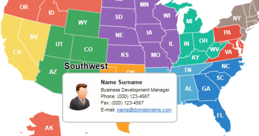
If your company has a wide network in the United States and you're developing a WordPress-based corporate website, you'll need a map that shows the locations of your sales reps. This kind of map provides visitors with information about the managers in each state or region.

Feb 07, 2026
Have you ever thought of displaying your company logo as a background watermark on any interactive map? Let us introduce yet another way to customize the look of our maps, this time by adding your business identity! Read on to find out what it may look like.
 Creating an Interactive Map of FIFA World Cup Best Results
Nov 18, 2022
World Cup 2018 has started! And to celebrate this, we’ve came up with a guide on creating an interactive infographics that displays the best result countries ever achieved in FIFA World Cup. Starting from scratch, the entire process takes as little as 15 minutes.
 U.S. Map with All Cities for WordPress Website
Nov 19, 2022
We found a quick solution to this problem. One of our clients wanted to add all the cities of the USA to the map and that these very cities would have had clickable links that would lead to different pages...
 Examples of Using the Map of Australia on Websites
Nov 24, 2022
An interactive map of Australia from Fla-shop.com is a plugin for WordPress-powered websites that allows placing geographical-related content into a corporate or standalone website with just a few clicks. In this article, we collected 10 inspirational examples of the Australia Map plugin for WordPress.
 Creating Infographics with the US Map Plugin
Apr 07, 2023
Infographics and data visualization are essential tools for attracting attention to a webpage. Regardless of a website's topic, infographics can impress visitors with vivid visualizations of vast amounts of data.
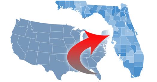 Drill-down Map of the USA for WordPress: Here is How You Can Configure 3000+ Counties in Minutes Using CSV Importing
May 30, 2022
Let's face it: manual configuration of US counties is not an easy task. Indeed, the USA map has 3000+ of counties in total. Imagine you need to setup the landing pages, the contact information and possibly the visual style for each one of them. Even if you need to adjust only a half of counties, this is still a whole lot of work.